Skip to content
← Tags

#Robotics (26)

DeFM: Learning Foundation Representations from Depth for Robotics

DeFM: Learning Foundation Representations from Depth for Robotics

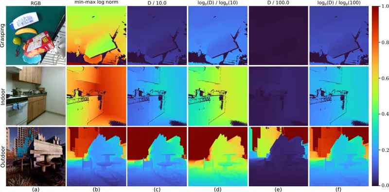
Depth sensors are widely deployed across robotic platforms, and advances in fast, high-fidelity depth simulation have enabled robotic policies trained on depth observations to achieve robust sim-to-real transfer for a wide range of tasks. Despite this, representation learning for depth modality remains underexplored compared to RGB, where large-scale foundation models now define the state of the art. To address this gap, we present DeFM, a self-supervised foundation model trained entirely on depth images for robotic applications. Using a DINO-style self-distillation objective on a curated dataset of 60M depth images, DeFM learns geometric and semantic representations that generalize to diverse environments, tasks, and sensors. To retain metric awareness across multiple scales, we introduce a novel input normalization strategy. We further distill DeFM into compact models suitable for resource-constrained robotic systems. When evaluated on depth-based classification, segmentation, navigation, locomotion, and manipulation benchmarks, DeFM achieves state-of-the-art performance and demonstrates strong generalization from simulation to real-world environments. We release all our pretrained models, which can be adopted off-the-shelf for depth-based robotic learning without task-specific fine-tuning. Webpage: https://de-fm.github.io/

Manthan Patel, Jonas Frey, Mayank Mittal · 127 views · Jan 26, 2026
DepthSelf-Supervised Learning
Jan 26, 2026

StageVLN: Spatial and Trajectory Auxiliary Guidance for Efficient Vision-Language Navigation

StageVLN: Spatial and Trajectory Auxiliary Guidance for Efficient Vision-Language Navigation

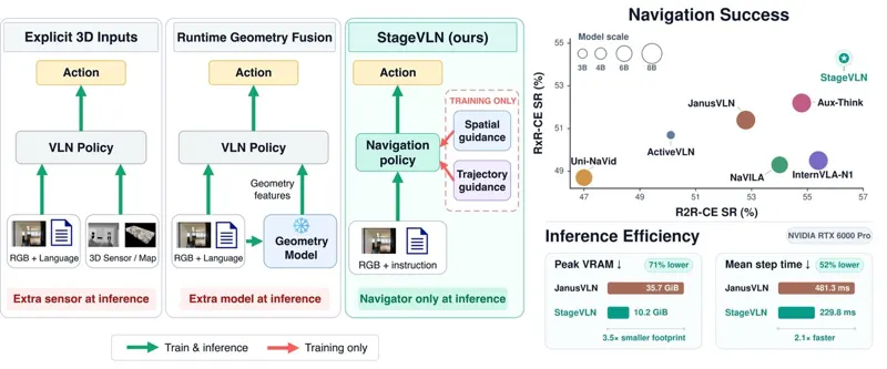
Vision-and-Language Navigation (VLN) policies increasingly benefit from strong semantic priors provided by large vision-language models (VLMs). However, standard action supervision does not explicitly encourage intermediate representations to preserve scene geometry, relative orientation, or global episode progress. Incorporating depth estimators, explicit maps, point clouds, or geometry foundation models at inference can provide such structure but introduces additional computation, memory overhead, and architectural dependence during deployment. We introduce StageVLN, a training framework that shapes navigation representations through privileged spatial and trajectory guidance while preserving the original inference pathway. A frozen geometry foundation model provides multi-level spatial guidance to hierarchical navigator states, while relative-heading and expert-route progress objectives provide complementary trajectory-state supervision. All auxiliary components are used only during training and removed at deployment. On R2R-CE validation-unseen, StageVLN achieves 56.3% SR and 51.4% SPL with a 4B-parameter backbone, without an additional geometry encoder at inference. On RxR-CE, it achieves 54.3% SR without additional navigation training data or a geometry encoder at inference.

Anh Dao, Quan-Dung Pham, Le Danh Vinh · 243 views · Oct 5, 2026
Vision-language navigationEmbodied AI
Oct 5, 2026
SILICA: Repurposing Diffusion Priors for Joint Glass Segmentation and Depth Estimation

SILICA: Repurposing Diffusion Priors for Joint Glass Segmentation and Depth Estimation

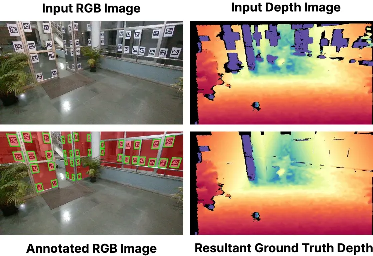
Standard depth sensors systematically fail on transparent surfaces, creating corrupted 3D maps and severe navigation hazards. While specialized hardware sensors can detect glass, they lack modularity and have extensive hardware dependencies. Consequently, learning-based monocular depth estimation has emerged as a compelling alternative. However, domain-specific glass-aware monocular depth estimators struggle with unfamiliar indoor layouts; restricted by the severe scarcity of real-world glass depth annotations, they fail to generalize zero-shot to new settings. This motivates us to explore whether the extensive priors of text-to-image diffusion models can enable generalizable perception of transparent surfaces. We introduce SILICA, a unified pipeline leveraging these priors to jointly predict glass segmentation and glass-aware depth. This mutual information exchange establishes a robust spatial hierarchy, entirely eliminating the need for paired real-world glass depth annotations. Subsequently, we use the predicted segmentation mask to explicitly filter incorrect glass depth points from standard sensors, recovering accurate metric glass depth for downstream 3D mapping and autonomous collision avoidance. Supported by our novel Mirage 18k dataset, extensive experiments demonstrate that SILICA achieves remarkable zero-shot transfer across diverse, unseen environments, outperforming state-of-the-art models by almost 20% and setting a new benchmark for transparent surface perception.

Tarun R, Anuj Verma, Laksh Nanwani · 420 views · Jul 27, 2026
RoboticsRobots
Jul 27, 2026
Accuracy potential of visual localization exploiting high-end street-level imagery

Accuracy potential of visual localization exploiting high-end street-level imagery

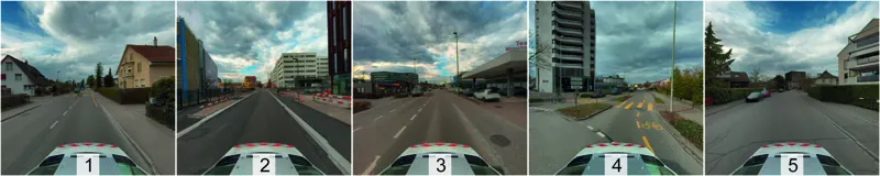
Accurate and reliable pose information with respect to a reference frame is increasingly demanded across applications such as autonomous navigation, surveying, robotics, and augmented and mixed reality. Visual localization can serve as a complementary positioning modality to GNSS, whose applicability and accuracy are often limited. Yet, the accuracy potential of visual localization has not been systematically investigated against survey-grade demands. This is mainly due to the lack of publicly available, large-scale outdoor datasets with ground-truth poses in the sub-centimeter range. In this work, we address both gaps. We introduce a scalable visual localization pipeline that employs precisely georeferenced, high-resolution street-level imagery directly as the scene representation. It combines prior-guided reference candidate selection with on-the-fly local Structure-from-Motion reconstruction and PnP-based pose estimation. We further present the FHNW Muttenz dataset, a real-world dataset covering a contiguous 10 km street network mapped in two mobile mapping campaigns approximately 1.5 years apart. It consists of high-resolution reference imagery and query sequences acquired by four different cameras across five representative scenes. All images are precisely co-registered, yielding 6-DoF ground-truth poses in the sub-centimeter range. Using this dataset, we evaluate the accuracy potential of visual localization. Our experiments demonstrate median pose accuracies in the range of 1-5 cm for translation and 0.05-0.1° for rotation, reaching as low as 1 cm and 0.03° under favorable conditions. These results show that visual localization can complement survey-grade GNSS positioning, paving the way for 3D geospatial data acquisition using consumer devices and fully automated georeferencing approaches. The dataset is publicly available at: https://fhnw-muttenz-vl-dataset.github.io/.

Jonas Meyer, Stephan Nebiker, Pascal Theiler · 398 views · Jul 27, 2026
RoboticsRobots
Jul 27, 2026

As an Amazon Associate, we earn from qualifying purchases.