PAPER DEEP DIVE
LG-VLN: A Zero-Shot Vision-and-Language Navigation Framework with LangGraph State Orchestration
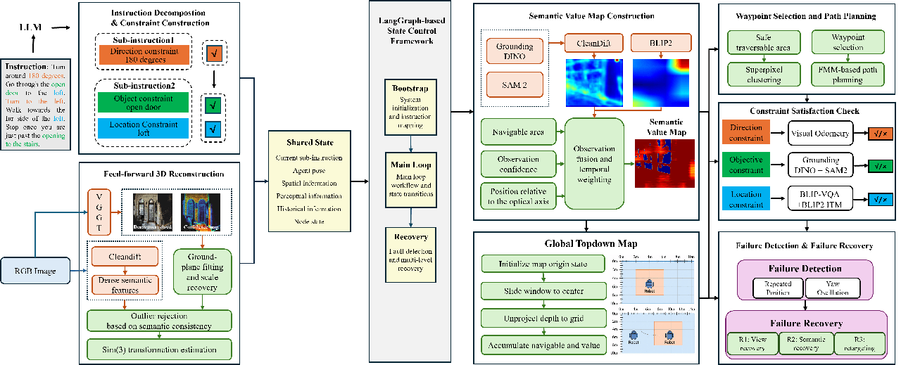
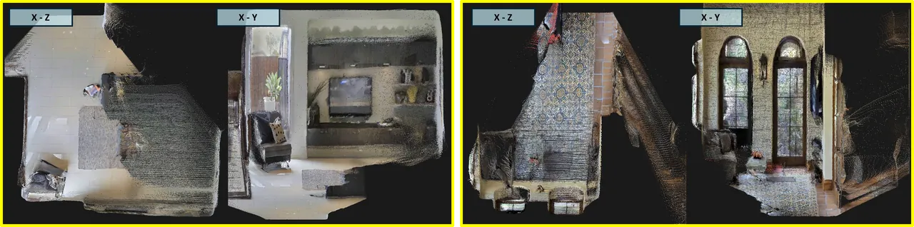
LG-VLN is a zero-shot VLN-CE framework that uses only monocular RGB. VGGT estimates depth, camera poses, and point clouds online, while CleanDIFT supplies shared dense features for correspondence filtering and semantic value construction. BLIP-2 image-text relevance is fused with target-reference similarity, and Grounding DINO with SAM 2 localizes objects. LangGraph orchestrates instruction tracking, mapping, planning, action execution, and staged recovery over persistent state. On a fixed 550-episode R2R-CE val-unseen subset, it reaches 21.3% SR, 12.1% SPL, and 7.85 m NE. The public repository is only a scaffold at the inspected commit and does not yet reproduce the paper.
Paper identity and bottom line
Title: LG-VLN: A Zero-Shot Vision-and-Language Navigation Framework with LangGraph State Orchestration.
Authors: Jianhe Zhao, Yanhua Qiu, Zhiyu Zhang, Zibo Zhao, and Jinhua Xie.
Paper: https://arxiv.org/abs/2609.15098. This analysis follows the first arXiv version dated 14 September 2026. The paper is primarily categorized under computer vision and is cross-listed in robotics.
Code status: The public repository is https://github.com/GKGUK/LG-VLN under the MIT license. I inspected commit ff357943b4c3b778ad20405cd08882ee812f46e0. It contains a README, configuration, license, a package stub, and an environment-check script. The reconstruction, semantic-value, planner, recovery, and Habitat evaluation modules described in the paper are absent. The repository therefore proves public availability, not reproducibility at the inspected commit. Directory names and README promises are not treated here as implementation evidence.
Bottom line: LG-VLN combines online monocular 3D reconstruction, a dense feature representation shared by geometry and semantics, and explicit state-machine recovery to navigate continuous environments without task-specific policy training.
Why the problem is difficult
Vision-and-language navigation in continuous environments asks an embodied agent to follow a route description while selecting low-level movement. The environment does not provide a graph of valid waypoints. The agent must decide which surfaces are traversable, maintain spatial memory after objects leave the camera, estimate its own motion, and determine when a described subgoal has actually been completed. Language interpretation is necessary, but neither sufficient nor reliable in isolation.
Many zero-shot systems reduce this burden by using panoramic RGB-D input, depth sensors, odometry, or a waypoint predictor trained on navigation data. Those inputs can stabilize geometry and frontier planning, but they also narrow the deployment claim. The paper asks whether a normal monocular camera is enough to estimate depth, camera pose, and point clouds online while preserving enough metric structure for continuous decisions.
A second issue is representation mismatch. Geometric systems often match keypoints or learned reconstruction features, while semantic navigation uses a separate vision-language embedding. Each representation may be locally reasonable, but the pair can disagree on repetitive structures, low-texture walls, or visually similar furniture. A geometric match may survive RANSAC while linking semantically different regions. A semantic heatmap may be smooth enough to identify a room but too coarse to separate a nearby doorway from an irrelevant wall. Sharing dense diffusion features gives the paper one representation for rejecting bad inter-frame correspondences and for propagating target-specific visual evidence.
The third issue is control over a long horizon. Instructions usually contain ordered clauses. Perception, planning, and stopping can fail independently. A fixed pipeline does not naturally answer whether the current failure came from the active instruction, a missed target, a bad waypoint, a blocked corridor, or an incorrect map update. LG-VLN represents these decisions as a persistent graph with explicit routing among initialization, normal navigation, recovery, and termination.
The contribution is therefore best understood as an integration study. No new vision-language foundation model is trained. The system composes VGGT, CleanDIFT, BLIP-2, Grounding DINO, SAM 2, and LangGraph. Its evidence must be judged on whether the composition improves a constrained monocular setting, not on whether each foundation model is individually novel.
Task setup and state
The agent receives a language instruction and a monocular RGB frame. At each decision it chooses Forward, TurnLeft, TurnRight, or Stop. Habitat applies a 0.25-meter translation for Forward and a 30-degree rotation for either turn. The visual input is restricted to the current first-person color image. The system does not consume simulator depth, ground-truth pose, semantic segmentation, odometry, or a prior map.
The representation includes a world frame, body frame, camera frame, and an agent-centered local map. The world frame is initialized from the first reliable geometric observation, with its vertical direction aligned to the estimated ground. The local map remains aligned with the world axes and translates with the agent. Camera rotation does not rotate the map, which simplifies temporal fusion and short-range planning.
Inter-frame geometry is represented with similarity transformations rather than strict rigid motions because the reconstructed scale can drift. The shared graph state records the active sub-instruction, current pose, global map, navigation history, action outcome, and failure status. Entering recovery does not reset the global map. It replaces or reevaluates a local hypothesis while preserving earlier spatial evidence.
Initialization rotates the camera over a full panorama, fits ground observations, estimates scale, and chooses an initial heading. An explicit turn in the instruction takes precedence over a purely semantic heading choice. The scan is treated as a pre-navigation sensing stage and is excluded from the 150-action evaluation budget.
How the system works
State orchestration
LangGraph provides the control structure. A router examines shared state and selects an active branch. A branch updates both state and observations, and the result becomes the input to the next decision. At a high level,
$$ n_t=\rho(\mathbf{s}_t),\qquad \mathbf{s}_t^{+}=F_{n_t}(\mathbf{s}_t,o_t). $$
Here $\rho$ selects the branch from state $\mathbf{s}_t$, and $F_{n_t}$ applies that branch with observation $o_t$. The practical consequence is inspectability: instruction progress, semantic-cache validity, map state, and failure evidence survive across iterations. Recovery can suspend a waypoint without discarding the world map or rewriting the episode from scratch.
graph TD
  A[Monocular RGB] --> B[VGGT
depth and pose]
  A --> C[CleanDIFT
dense features]
  B --> D[Semantic correspondence filter
bounded Sim3]
  D --> E[World-aligned BEV map]
  C --> F[Visual-reference similarity]
  A --> G[BLIP-2
image-text relevance]
  F --> H[Confidence-weighted fusion]
  G --> H
  H --> E
  E --> I[SLIC regions
reachable set]
  I --> J[FMM local path]
  J --> K[Forward or turn]
  K --> L{Persistent stagnation}
  L -- no --> A
  L -- yes --> M[Viewpoint recovery]
  M --> N[Semantic recovery]
  N --> O[Geometric exploration]
  O --> A
Metric scale from a known camera height
VGGT predicts relative depth, camera information, and point maps from the image stream. These predictions have no inherent meter scale. The system fits a ground plane using high-confidence ground points from the initialization panorama. If the normalized plane normal is $\hat{\mathbf{n}}_t$ and its offset is $\hat{b}_t$, the camera-to-ground distance in reconstruction units is the absolute offset. With known camera mounting height $h_{\mathrm{cam}}$, each valid view proposes
$$ \hat{s}_t=\frac{h_{\mathrm{cam}}}{|\hat{b}_t|}. $$
The view is accepted only when it has enough ground inliers, a plausible normal, a bounded fitting residual, and a scale inside the valid interval. The episode scale is the robust center of valid observations:
$$ s_0=\operatorname{median} \left(\left\{\hat{s}_t\mid t\in\mathcal{F}_{\mathrm{valid}}\right\}\right). $$
The median reduces sensitivity to one bad plane fit. Depth and point maps are then multiplied by this common scale. This produces an approximate metric reference, but it does not track later scale changes. That distinction returns in the depth analysis and in the limitations.
Semantic filtering before registration
CleanDIFT features are interpolated to image resolution and normalized, giving a dense semantic descriptor for each pixel. For a proposed 3D correspondence between adjacent frames, the system computes descriptor similarity. A match survives only if semantic similarity and both VGGT confidence values exceed their thresholds. This adds a semantic veto to the usual geometric consensus problem. It is especially relevant for repeated door frames, similar windows, and low-texture regions where a geometry-only matcher can choose a plausible but incorrect association.
The surviving matches estimate a bounded similarity transform:
$$ \mathbf{x}_i^{t}\simeq s_{t-1,t}\mathbf{R}_{t-1,t}\mathbf{x}_i^{t-1} +\mathbf{t}_{t-1,t},\qquad \left|\log s_{t-1,t}\right|\leq\epsilon_s. $$
RANSAC supplies an initial transform, followed by a confidence-weighted robust refinement. The logarithmic bound prevents one frame pair from applying an extreme scale correction. If registration has too few inliers or violates the scale bound, the system retains the previous pose and temporarily excludes the observation from map fusion. This is a conservative behavior: a missing update is preferred to a confidently corrupted map.
Instruction constraints as state
The instruction is segmented using navigation verbs, sequential connectives, changes in spatial relations, and syntax. A lightweight language model normalizes entities and relations. Object, location, turn, and relative-motion constraints are stored separately. Backward motion is converted into a turn followed by a forward action so that the low-level action vocabulary remains unchanged.
For active sub-instruction $k_t$, completion is the product of all binary constraint satisfactions:
$$ \chi_t^{\mathrm{done}}= \prod_{c\in\mathcal{C}_{k_t}}\operatorname{Sat}_t(c). $$
Object constraints use Grounding DINO detections and SAM 2 masks. Mask pixels with usable depth are projected into the world map, and the target must be observed consistently before it is accepted. Location constraints use visual question answering and a short state for entering, staying in, and leaving a region. Direction constraints distinguish accumulated rotation from short-window displacement. This prevents a stationary turn from satisfying “move to the left” and prevents lateral displacement from satisfying “turn left.”
Fusing two semantic signals
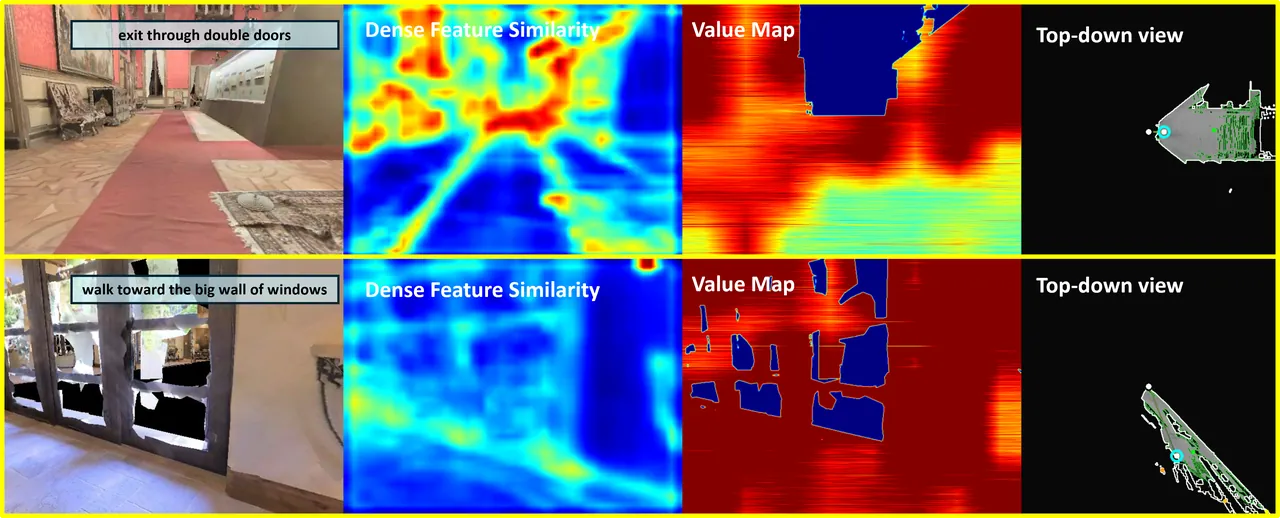
CleanDIFT compares the current view with visual references linked to the active target. BLIP-2 measures local image-text relevance. The first signal preserves fine-grained appearance correspondence; the second can recover instruction-conditioned meaning when the current view differs from earlier target pixels. The evidence maps are fused by reliability:
$$ \mathbf{E}_t= \frac{\beta_aq_t^a\mathbf{A}_t+ \beta_bq_t^b\mathbf{B}_t} {\beta_aq_t^a+\beta_bq_t^b+\epsilon}. $$
If one source is unavailable, the other still contributes. The fused value is then weighted by geometric validity, viewing angle, range, surface support, traversability, and registration confidence. Historical observations are reprojected into the current camera and fused only where navigation and reprojection masks are valid:
$$ \mathbf{V}_t^{\mathrm{img}}=\mathbf{M}_t^{\mathrm{nav}}\odot \frac{ \widetilde{\mathbf{Q}}_t^{\mathrm{val}}\odot \widetilde{\mathbf{V}}_t^{\mathrm{img}} +\eta\mathbf{M}_t^{\mathrm{rep}}\odot \widehat{\mathbf{Q}}_{t-1\rightarrow t}\odot \widehat{\mathbf{V}}_{t-1\rightarrow t}} { \widetilde{\mathbf{Q}}_t^{\mathrm{val}} +\eta\mathbf{M}_t^{\mathrm{rep}}\odot \widehat{\mathbf{Q}}_{t-1\rightarrow t}+\epsilon}, $$
$$ \mathbf{Q}_t^{\mathrm{val}}=\mathbf{M}_t^{\mathrm{nav}}\odot \operatorname{clip}\left( \widetilde{\mathbf{Q}}_t^{\mathrm{val}} +\eta\mathbf{M}_t^{\mathrm{rep}}\odot \widehat{\mathbf{Q}}_{t-1\rightarrow t},0,1 \right). $$
The mask rejects non-navigable pixels, foreground occlusion, out-of-bounds projections, negative depth, and inconsistent correspondence. Repeated views increase confidence in a grid cell. When the active sub-instruction changes, old values are attenuated instead of deleted. The new target receives priority, while useful exploration memory remains available.
From global map to local motion
The global top-down map stores traversability, occupancy, exploration, observation counts, semantic values, and dense features. Ground-supported points contribute to free space and elevated structures contribute to occupancy. Occupation wins when the layers conflict. Motion consistency adds another correction: if Forward repeatedly produces less visual displacement than requested, the attempted cells receive stronger obstacle evidence.
Waypoints are restricted to the agent's connected safe component:
$$ \mathcal{R}_t=\operatorname{CC} \left( \left\{ \mathbf{x}\mid \mathbf{N}_t^{\mathrm{nav}}(\mathbf{x})=1,\; \mathbf{N}_t^{\mathrm{occ}}(\mathbf{x})=0,\; \operatorname{dist}(\mathbf{x},\Omega_t^{\mathrm{occ}}) >d_{\mathrm{safe}} \right\}, \mathbf{p}_t \right). $$
Semantic values and features are clustered with a semantics-augmented SLIC procedure. Each valid cluster proposes a representative point. The score of candidate $\mathbf{w}$ is the mean value over its region:
$$ J_t(\mathbf{w})= \frac{1}{|\mathcal{U}(\mathbf{w})|} \sum_{\mathbf{x}\in\mathcal{U}(\mathbf{w})} \mathbf{V}_t^{\mathrm{map}}(\mathbf{x}), \qquad \widehat{\mathbf{w}}_t= \arg\max_{\mathbf{w}\in\mathcal{A}_t^{\mathrm{wp}}} J_t(\mathbf{w}). $$
Region averaging suppresses isolated high-value pixels caused by viewpoint noise. Hysteresis keeps a valid previous waypoint when a slightly higher candidate appears, and history suppresses repeated bad decisions. FMM computes a geodesic field inside the safe component. A short-horizon goal is converted to turn or forward actions by comparing its bearing with the current heading. Reaching an intermediate waypoint triggers replanning, not sub-instruction completion. Stop is allowed only after the final constraints and target neighborhood are satisfied.
Failure detection and staged recovery
The graph watches ineffective forward actions, spatial recurrence, heading oscillation, and a lack of waypoint progress over temporal windows. It does not call recovery after a single collision. A stagnation counter accumulates persistent evidence and decays after sustained movement or instruction progress. Once the threshold is crossed, the active waypoint is suspended.
Recovery has three levels. Viewpoint recovery rotates in place and reevaluates target relevance, addressing occlusion and a poor field of view. Semantic recovery discards the current target-specific evidence and rebuilds detection, visual references, and image-text relevance while keeping the geometric map. Geometric exploration selects a reachable frontier when no reliable semantic waypoint exists. It gains a new viewpoint but does not replace the active instruction. Successful recovery resumes the interrupted sub-instruction; repeated failure ends the episode.
Evaluation and evidence
The experiments use Habitat-Sim and Matterport3D scenes. The authors sample 50 episodes from each of the 11 unseen scenes in R2R-CE val-unseen, producing a fixed 550-episode subset. All methods use a 3-meter success threshold and 150 low-level actions. LG-VLN receives only egocentric monocular RGB and does not read simulator ground truth during navigation. The main comparison mixes system settings: NavGPT uses a prebuilt discrete graph, Open-Nav uses panoramic RGB-D and a task-trained waypoint predictor, InstructNav uses RGB-D and ground-truth poses, and CA-Nav uses RGB-D with odometry.
| Method | SR | SPL | OSR | NE |
|---|---|---|---|---|
| NavGPT | 31.8% | 26.8% | 40.9% | 9.75 m |
| Open-Nav | 26.4% | 23.2% | 31.6% | 7.99 m |
| InstructNav | 15.1% | 6.7% | 25.1% | 7.84 m |
| CA-Nav | 22.4% | 9.3% | 43.7% | 8.76 m |
| LG-VLN | 21.3% | 12.1% | 29.5% | 7.85 m |
LG-VLN reaches 21.3% success, close to CA-Nav's 22.4% despite removing RGB-D and odometry. Its SPL is 12.1%, higher than CA-Nav's 9.3%. The Oracle success rate tells the opposite part of the story: LG-VLN is 14.2 percentage points below CA-Nav, indicating that its conservative exploration enters the 3-meter goal region less often. The paper interprets this through frontier behavior and fixed-scale geometry. The system trades some coverage for shorter successful trajectories rather than dominating every metric.
NavGPT and Open-Nav have higher success rates, but their inputs and navigation assumptions are not equivalent. The defensible claim is that strict monocular observations can support a competitive zero-shot system under the fixed subset, not that LG-VLN is the best method overall.
Ablation and geometric error
The semantic-source ablation removes one value-map channel at a time. The full model reaches 21.3% SR. Removing CleanDIFT reduces SR to 3.0%, while removing BLIP-2 reduces it to 12.0%. CleanDIFT is therefore the dominant spatial signal in this particular value-map pipeline, while BLIP-2 adds instruction-conditioned evidence beyond visual appearance. The authors correctly limit the interpretation to the fusion framework rather than claiming a general foundation-model ranking.
| Semantic configuration | SR | SPL | OSR | NE |
|---|---|---|---|---|
| Full | 21.3% | 12.1% | 29.5% | 7.85 m |
| Without CleanDIFT value | 3.0% | 2.1% | 7.8% | 8.70 m |
| Without BLIP-2 value | 12.0% | 9.3% | 16.2% | 8.92 m |
The geometry ablation separates depth and pose effects. Oracle depth and pose produce 24.9% SR, 17.7% SPL, and 6.80-meter NE. Predicted depth with ground-truth pose produces 24.2%, 15.2%, and 7.04 meters. Full online geometry drops to 21.3%, 12.1%, and 7.85 meters. The transition from ground-truth to online pose adds 0.81 meters of final error, compared with 0.24 meters when ground-truth depth is replaced. Pose error is the larger failure source in this setup.
| Geometry configuration | SR | SPL | NE |
|---|---|---|---|
| Oracle depth and pose | 24.9% | 17.7% | 6.80 m |
| Predicted depth and oracle pose | 24.2% | 15.2% | 7.04 m |
| Full online geometry | 21.3% | 12.1% | 7.85 m |
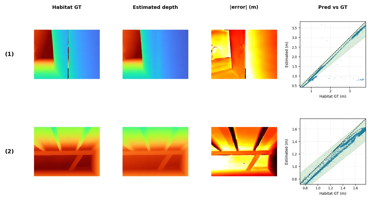
The depth study makes the scale problem visible. Under the fixed episode scale, AbsRel has a mean of 0.5874 and a median of 0.2643. After per-frame median alignment, those values fall to 0.0493 and 0.0319. The difference between the fixed and aligned results indicates that most frames preserve relative depth better than the global scale suggests. Pearson correlation has a mean of 0.9107 and a median of 0.9723. Large errors cluster around object boundaries and depth discontinuities where the prediction is smoother than the range image.
Pose evaluation isolates the semantic filter. Relative translation error falls from 0.150 to 0.092 meters, a 38.7% reduction. Absolute trajectory error changes only from 0.322 to 0.318 meters. This pattern is consistent with pairwise registration improvement rather than global trajectory optimization. The paper does not overstate the null ATE improvement, which is useful because the scale and drift story remains unresolved.
Runtime and deployment cost
The reported per-call times are 178 milliseconds for VGGT, 179 milliseconds for CleanDIFT, 602 milliseconds for Grounding DINO plus SAM 2, 52 to 72 milliseconds for BLIP-2 image-text matching, and 86 milliseconds for map fusion and FMM planning. Geometry and dense features run on every frame. The expensive detector, segmenter, and text matcher are event-driven and refresh only after target changes, sub-instruction transitions, recovery, or a sufficiently different viewpoint.
This scheduling makes the system more plausible than a design that invokes every model at every action, but the measured requirement still assumes an RTX 5090 with 32 GB of memory. The paper does not report end-to-end latency, peak memory, energy, embedded performance, or long-duration thermal behavior. A robot deployment cannot infer real-time feasibility from isolated module timings. Recovery adds panoramic and semantic recomputation, so the cost distribution also has a long tail that the table does not capture.
Limitations and a stricter reading
The first author-stated limitation is the single fixed global scale. The system estimates one scale during initialization and keeps it for the episode. Bounded inter-frame similarity can absorb some local variation, but it cannot restore an absolute meter scale after substantial drift. The gap between fixed-scale and median-aligned depth error is direct evidence. Because waypoint clearance, recovery radius, and the 3-meter success threshold use metric units, scale error affects planning and stopping rather than remaining a reporting artifact.
The second author-stated concern is the single-run result on a fixed 550-episode subset. The paper says the SR differences are small enough that stronger conclusions require more episodes or repeated runs. It does not provide variance across seeds, confidence intervals, significance tests, or sensitivity to initialization headings and foundation-model versions. A multi-model system has several sources of run-to-run and model-version variation, so one point estimate is weak evidence for close rankings.
Third, the inspected repository is a scaffold. It cannot confirm parameter defaults, map resolution, semantic thresholds, stagnation counters, or reproduction of Habitat integration. The appendix is unusually detailed, but implementation detail is not the same as executable reproduction. Claims about shared features and recovery should be revisited when the real modules are released.
Fourth, the main comparison combines discrete-graph, panoramic RGB-D, task-trained waypoint, and monocular continuous settings. The table makes these differences visible, which is important, but the reader still cannot attribute every performance gap to sensing alone. A full val-unseen result, multiple balanced subsets, and per-scene breakdown would provide a stronger generalization argument.
Fifth, the paper does not quantify how often each recovery branch fires or what fraction of successes depends on recovery. The architecture presents a credible response to stagnation, yet the evidence remains aggregate. Recovery traces, action-budget use, and failure-mode counts would show whether the graph is a genuine control contribution or mostly a software organization layer around the other modules.
Conclusion
LG-VLN shows that monocular online geometry, dense visual correspondence, instruction constraints, and explicit control state can be combined into a functioning zero-shot navigation loop. The strongest evidence is not the headline success number in isolation. It is the paired semantic ablation, where shared CleanDIFT features matter in both geometry filtering and value-map construction, and the geometry ablation, where pose error dominates final navigation error. Those results point to concrete next steps: online scale consistency, repeated evaluation, and executable code.
The paper is also a reminder that system integration papers need two kinds of reproducibility. The text must expose the algorithmic choices, and the repository must expose the actual control and evaluation path. LG-VLN does the first substantially better than the second at the inspected commit. Until the implementation matches the paper, its result should be read as a careful feasibility study rather than a fully validated robotics stack.
The useful claim is not that one global monocular scale solves continuous navigation. It is that shared dense evidence can serve geometry and semantics at the same time, while explicit state makes the inevitable failures inspectable enough to recover from.